
 S.E.E.
wayfinder device
Stephen Morgan
Stephen_Patrick_Morgan@hotmail.com
Metropolitan State College of Denver
Colorado, USA
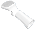
A radar scanner embedded in a belt buckle continually maps the terrain directly ahead of the user and wirelessly transmits this information to the second device, a palm-mounted pad that translates the information into a 3D representation of
the immediate vicinity. The visually impared user can then accurately direct themselves through an unfamiliar environment by detecting a variety of objects in their area using tactile feedback from the pad.
S.E.E. also includes a GPS feature, combined with a database of landmarks and addresses of local venues, the unit can help guide the user to specific sites.
S.E.E.
wayfinder device
Gavin Ivester: "The feature that hooked me was the application of GPS-if you've ever navigated around a strange city at night with a really good nav system in a car, its potential usefulness to a blind pedestrian is clear. And it wouldn't be that big a leap to create a feedback loop that utilizes this product's users to continually improve the detail of the maps and directions."
Anne Ellegood: "I think this is simply a great idea to use available technology and apply it to the needs of a particular group. It makes sense that in our digital age, a seeing eye dog can potentially be replaced by an electronic device."
 S.E.E.
wayfinder device
Stephen Morgan
Stephen_Patrick_Morgan@hotmail.com
Metropolitan State College of Denver
Colorado, USA
Age: 31
Design Education:
B.A. Industrial Design Metropolitan State College, Denver, CO
Design Inspiration:
My inspiration comes from my desire to help create interesting,
aesthetically unique, and innovative products that truly benefit the user.
Design Heroes:
Achille Castiglioni, Karim Rashid, Droog
Comments:
It's gratifying to come up with an idea that can really help someone.


 S.E.E.
wayfinder device
Stephen Morgan
Metropolitan State College of Denver
Colorado, USA
A radar scanner embedded in a belt buckle continually maps the terrain directly ahead of the user and wirelessly transmits this information to the second device, a palm-mounted pad that translates the information into a 3D representation of the immediate vicinity. The visually impared user can then accurately direct themselves through an unfamiliar environment by detecting a variety of objects in their area using tactile feedback from the pad.
S.E.E. also includes a GPS feature, combined with a database of landmarks and addresses of local venues, the unit can help guide the user to specific sites.