e
REscan: A Helmet-Based System for Scanning and Capturing 3D Spaces, Hands-Free
For my design job I use a $2,000 Leica Geosystems laser to measure interior and exterior spaces. It's an amazing tool, but it can be fiddly, and it requires I do detailed drawings of the space first, so I have a place to scribble the numbers down.
My approach is fine for residential, but it's not viable for workers who have to measure vast industrial or commercial spaces, like factories, airports or shopping malls. A company called Radius Innovation & Development has designed a brilliant system that meets their needs, and it's not a handheld laser. It's a helmet you wear on your head.
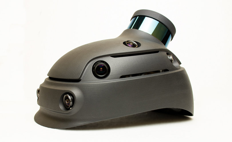
Called REscan, the helmet essentially has the array of cameras and lasers that self-driving cars do, just up on your dome. Best of all, it's hands-free, so you can carry things, open doors, take notes, sketch, etc. as you're scanning and capturing.
"We capture indoor and outdoor locations as fast as you can walk through them. No need to shut down or empty spaces, our software automatically excludes people from the scans," the company writes.

"One person can capture up to 250,000 sq.ft. per hour while navigating stairs, opening doors, fitting into high street shops, and capturing industrial spaces."


One downside is that you've got to wear these dorky smart glasses that pair with the helment. They let you know if you're in an area that still needs to be scanned or if you've already covered it.

The company's technology turns the captured scans into detailed 3D models, and the demo looks pretty stunning:
Enter a caption (optional)
-
oFavorite This
-
Q1Comment
Directory Company Profiles
Core77
Industrial Design
Resources
Industrial Design
Resources
-
Core77 Directory
Find the Best Industrial Design CompaniesGo -
 Ammunition
Founded in 2007, Ammunition is led by partners Robert Brunner and Matt Rolandson. Our work is create...
-
Formation Design Group
Formation is a product design + development company focused on human centered design innovation. To ...
-
Hatch Duo, LLC
Founded by an award-winning team with over 20 years of combined product design experience, Hatch Duo...
-
ECCO Design
ECCO Design is a full service product design and innovation firm. We are a team of designers, resear...
-
DesignStein Studios, LLC
We are a team of industrial designers focused on developing products that are intended for tooling a...
-
HS Design
HSD believes the future is based on teamwork across many disciplines and collaboration with multiple...
-
Pushstart Creative
What is your future in a connected world? We create impactful strategies and build beautiful connec...
K
{Welcome
Create a Core77 Account
Already have an account? Sign In
By creating a Core77 account you confirm that you accept the Terms of Use
K
Reset Password
Please enter your email and we will send an email to reset your password.
Comments
This is pretty awesome. How accurate are the models? +/- 0.5"? What type of model data file is it? Can it be imported into Revit or SketchUp? Are all surfaces photos of actual surfaces? Is there an average file size per square meter? Are architecture firms using this?